
Las Vegas ZIP Area Coverage
The Clark County Valley ZIP boundary map, dated April 19, 2025, labels a broad set of Las Vegas-area ZIPs and nearby 890xx ZIPs. It is a local geography map, not a complete postal-delivery catalog. The selected rows show why a ZIP directory needs a second boundary check. The first group represents city and valley postal areas; the last rows show adjoining municipalities and a code whose classification was not verified in the map research.
| ZIP | Area shown in local geography | Postal convention | Record-search note |
|---|---|---|---|
| 89101 | Downtown and central Las Vegas | Las Vegas postal station | Confirm city limits parcel by parcel |
| 89106 | West Las Vegas and Historic Westside | Las Vegas postal station | Use the parcel for jurisdiction |
| 89109 | Strip and northeast resort corridor | Las Vegas postal station | Postal label can cover Paradise or unincorporated land |
| 89119 | South-central, airport, and UNLV vicinity | Las Vegas postal station | Check Paradise and city boundaries |
| 89134 | Summerlin and northwest valley | Las Vegas postal station | City and Clark County boundary varies |
| 89166 | Northwest growth area | Las Vegas postal station | Municipal line varies by parcel |
| 89030 | North Las Vegas | North Las Vegas route | Outside City of Las Vegas |
| 89150 | Special classification not verified | Station not located in research | Use USPS before assigning a status |
Post-office station assignments were not individually verified during the research. The table uses the Valley map’s area labels and the local postal convention only. For a deliverable address or a definitive preferred city, verify with USPS. For a record custodian, use the CityLimits, Place, or City or Unincorporated Town field rather than a ZIP alone.
Las Vegas ZIP Boundaries
Postal geography and municipal geography are different systems. A mailing line that says Las Vegas can include Paradise, Winchester, Enterprise, Spring Valley, or other unincorporated Clark County places. The Strip is the most visible example. Its mailing addresses often use Las Vegas even when the parcel is not within the City of Las Vegas. A ZIP polygon also does not prove that every address inside it is served by the same city department.
Use the Clark County Valley ZIP boundary map as a starting layer, then compare it with CityLimits, county boundary, and Place layers. The local map is an important geography aid, but it omits or does not classify several codes that may have special or post-office-box uses. A ZIP result should describe postal routing, not city residency or a current person at an address.
Las Vegas ZIP Postal Checks
The official USPS address lookup is the delivery-address check. Its By Address route accepts a company name as an optional field, requires a street address, city, and state, and can use an optional apartment, suite, or other unit detail. The tool also has City and State and Cities by ZIP routes. USPS cautions that a ZIP result does not confirm that a person or company is at the address.
| USPS lookup field | Input type | Use |
|---|---|---|
| Company | Optional text | Adds delivery context when relevant |
| Street address | Required text | Primary address lookup field |
| Apt, suite, or other | Optional text | Helps narrow a multi-unit address |
| City and state | Required text and dropdown | Sets the postal geography |
| ZIP code | Optional in address mode; required in Cities by ZIP | Verifies or reverses a known code |
Enter the full street address and unit when one exists. If USPS returns a different postal presentation, preserve both versions in the research notes. The postal answer may still need a local GIS check when an address is near a city line, a resort corridor, or an annexed or unincorporated area.
Las Vegas ZIP Parcel Crosswalk
For a property question, move from ZIP to the parcel rather than trying to search an owner by ZIP. The Clark County Assessor address form uses street number, direction, street name, type, and City or Town. It does not expose a ZIP field. The City or Town choice represents a legal boundary, not necessarily the mailing city, so leaving it blank can be safer when the jurisdiction is uncertain.
The official Assessor parcel-card view is shown here because it separates the owner and mailing address from the location or situs address. That distinction prevents a ZIP directory search from turning a correspondence address into a claim about the physical parcel.
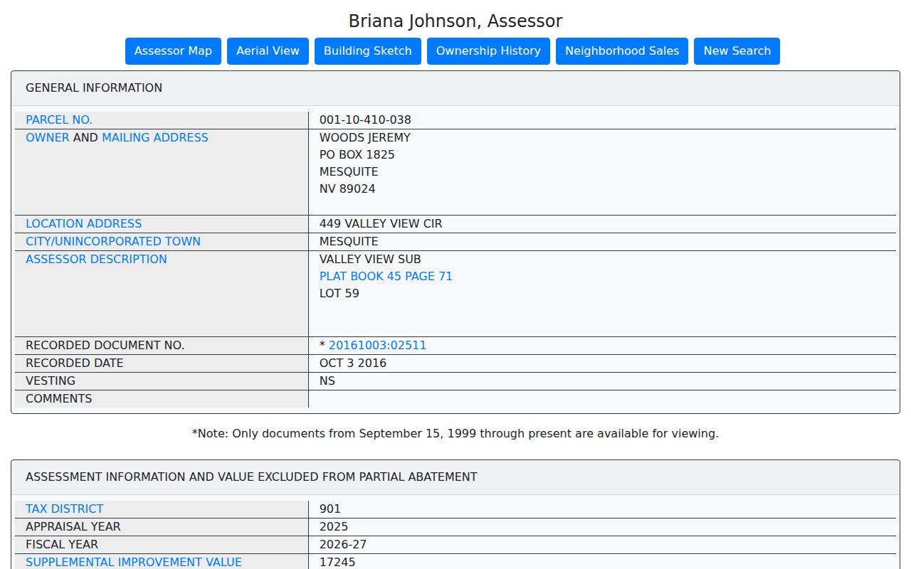
The sample card displays a Mesquite post office box for the owner and a different situs address, along with the parcel number, subdivision, recorded document, sale, land use, and structure information. The mailing address is not evidence that the owner resides at the situs. Record the APN, shown as an 11-digit number, because it is the stable link between GIS, the Assessor, and Recorder searches.
Finding Records by ZIP Code
A ZIP directory can narrow a geography, but the official record route is address and parcel based. Begin with USPS for the delivery ZIP, then use local ZIP and jurisdiction layers to locate the parcel. The Assessor can return the property record from an address or APN. Recorder searches use party name, parcel, document, date, or legal-description modes rather than a ZIP field. The voter portal also does not expose a ZIP search.
- Verify the full mailing address and ZIP with USPS, including a unit when needed.
- Open the county ZIP layer or local Valley map and note the ZIP polygon and adjacent ZIPs.
- Check CityLimits, Place, or City or Unincorporated Town to identify the records jurisdiction.
- Search the Assessor by address or APN and retain the situs, mailing address, parcel number, and legal description separately.
- Use the Recorder only when an instrument question requires the APN, party, or legal-description trail.
Once the ZIP has narrowed a question to one corridor or segment, the Las Vegas street directory has the detailed address-to-parcel route. A ZIP polygon is not a list of people who live inside it, and a property card does not list every person at a location.
Las Vegas ZIP Search Limits
The Recorder’s inspected tabs include Simple Search, Name, Parcel, Instrument, Document Type, Book and Page, Record Date, Total Value, and Legal Description. ZIP is not one of them. Its free online index reaches official records from 1988, while office and microfilm channels reach back to 1909. When an older deed is missing from the online search, take the APN, subdivision, lot, block, or legal description to the Recorder’s public research counter or copy route.
The county GISMO Open Web and City GIS services are map and query tools. County layers include Assessor, zoning, planned land use, imagery, ZIP, book-section, tract, and place data. City parcel services can expose ZIPCODE, ZIPMAIN, ZIPLUS4, owner, street components, land use, and geometry. GIS data is display-only and carries no warranty, so match the APN to the Assessor card before drawing an ownership conclusion.
Voter files may be grouped by county or district under the statutory route, but the inspected individual service is not a public ZIP browser. NRS 293.440 restricts permitted voter-list use, and inactive addresses are not current. Use the geometry and parcel chain for location research, then use election data only through the official channel and its stated rules.
Las Vegas ZIP Geography Keys
Several address keys can appear together without meaning the same thing. A situs address is the physical parcel location. A mailing address is the owner’s correspondence choice. An APN, or assessor parcel number, identifies the assessment parcel. A legal description identifies land through features such as a subdivision, lot, block, tract, or section. A ZIP is a postal routing label. Each key goes to a different kind of search.
- ZIP code and ZIP+4
- A ZIP identifies a broad postal area. ZIP+4 adds a smaller delivery segment and is verified through USPS.
- Post-office-box ZIP
- A code that may route post office boxes rather than define a neighborhood boundary. Classification needs USPS verification.
- Unique ZIP
- A code associated with a single organization or special use. Do not assign that status without USPS confirmation.
- Carrier route
- A postal delivery grouping within a ZIP. It is a routing unit, not a municipal boundary or resident roll.
Las Vegas ZIP History
Historic address work needs more than a modern ZIP. City Planning identifies Main Street and Fremont Street as local grid origins, with direction and address-number conventions that matter when normalizing an old address. Planning also notes that historical addresses can contradict the adopted system. A former number can be a geography problem rather than a failed record search.
Use the R.L. Polk 1957 to 1961 Arrow map, Sanborn references for 1928, 1943, and 1953, and UNLV street-name files covering 1930 to 1968 to bridge a changed street or number. The map and directory material helps locate the parcel’s historical setting; the Assessor APN and Recorder legal description help connect that setting to modern records. No verified citywide renumbering year was found, so do not assume one general conversion applies to every Las Vegas address.
ZIP Boundaries and Las Vegas Limits
A ZIP directory is a practical postal index, not a boundary decision or a person directory. The Valley map itself says nothing definitive about every special ZIP, post-office-box code, or unique institutional code. It also cannot show who currently occupies a parcel. Use USPS for delivery verification, GIS for geography, the Assessor for parcel administration, and the Recorder for recorded instruments.
When the map, mailing line, and parcel card disagree, retain the disagreement. The conflicting keys often point to the next useful source: a boundary layer, a legal description, an older map, or the appropriate city or county custodian.