
Las Vegas Neighbors Block Sources
Public sources answer different questions about a Las Vegas block. GIS can show a parcel’s geometry, ZIP, and jurisdiction. The Assessor parcel card adds the assessed owner, mailing address, situs, APN, land use, and legal description. Recorder records identify parties to instruments, but not every person at the location. Neighborhood association layers identify an organization and its contact details, not its full membership. Use the smallest source that answers the question and avoid turning property data into a broad household list.
| Block source | What it can show | Official access |
|---|---|---|
| Clark GISMO Open Web | Parcel geometry, zoning, planned land use, imagery, ZIP, and place layers | Free map and query view; display-only data |
| City parcel service | Parcel attributes, street components, ZIP fields, owner, land use, and geometry | City GIS REST layer |
| Clark County Assessor | Assessed owner, mailing and situs addresses, APN, legal description, sale and structure context | Free property search and office route |
| Clark County Recorder | Grantor, grantee, instrument, record date, parcel and legal-description context | Public index; image or historic route may require office access |
| Neighborhood and HOA layers | Association boundary, name, and contact metadata where published | City or county GIS and registration route |
| Historical archives | Old directories, maps, notices, and dated community clues | UNLV, Cahlan, newspaper, and library channels |
A parcel owner is not automatically a current occupant, and a mailing address may be a post office box, company address, or another state. The City or Unincorporated Town field is equally important. A Las Vegas mailing line can sit in Paradise, Winchester, Enterprise, Spring Valley, or another Clark County area, which changes the office that holds a permit, association, or local case record.
Las Vegas Neighbor Parcel Flow
The adjacent-parcel method keeps the work focused on one block. The City Planning instructions say to enter a directional address or APN without dashes, then select the result. The county and City services support map click and feature query. A public consumer buffer button was not verified, so use a parcel click, shared-boundary check, or the documented spatial query rather than claiming a radius tool that may not be visible.
- Find the subject address in City or county GIS and record the parcel’s jurisdiction before deciding which local office applies.
- Capture the APN, situs components, ZIP, lot or land-use detail, map or page, and any displayed owner field for the subject parcel.
- Click parcels that share a boundary or face the street, noting vacant land, common areas, parcel splits, and master parcels separately.
- Open the Clark County Assessor card for an APN when confirmation is needed. Compare its owner, mailing address, situs, and City or Unincorporated Town field.
- Use a Recorder APN search only for a narrow recorded-instrument question. Compare party role, date, and legal description before joining records.
This is a block method, not a street-wide roster. For a longer named-street ownership trail, use the Las Vegas by-street directory, which handles the address-to-APN and Recorder sequence in greater detail.
Las Vegas Neighbor Parcel Layer
The City of Las Vegas parcel layer contains structured fields for owner, address components, ZIPCODE, ZIPMAIN, ZIPLUS4, street direction and type, old page or lot values, land use, and geometry. It is useful for normalizing an address and seeing which adjacent features form the physical block. City services also include CityLimits, ZipCodes, Jurisdictions, Precincts, and Wards, which help prevent a postal-label mistake.
The captured City parcel-layer screen shows the attributes available for a Las Vegas parcel check. It documents a map-data schema, not a current occupancy record.
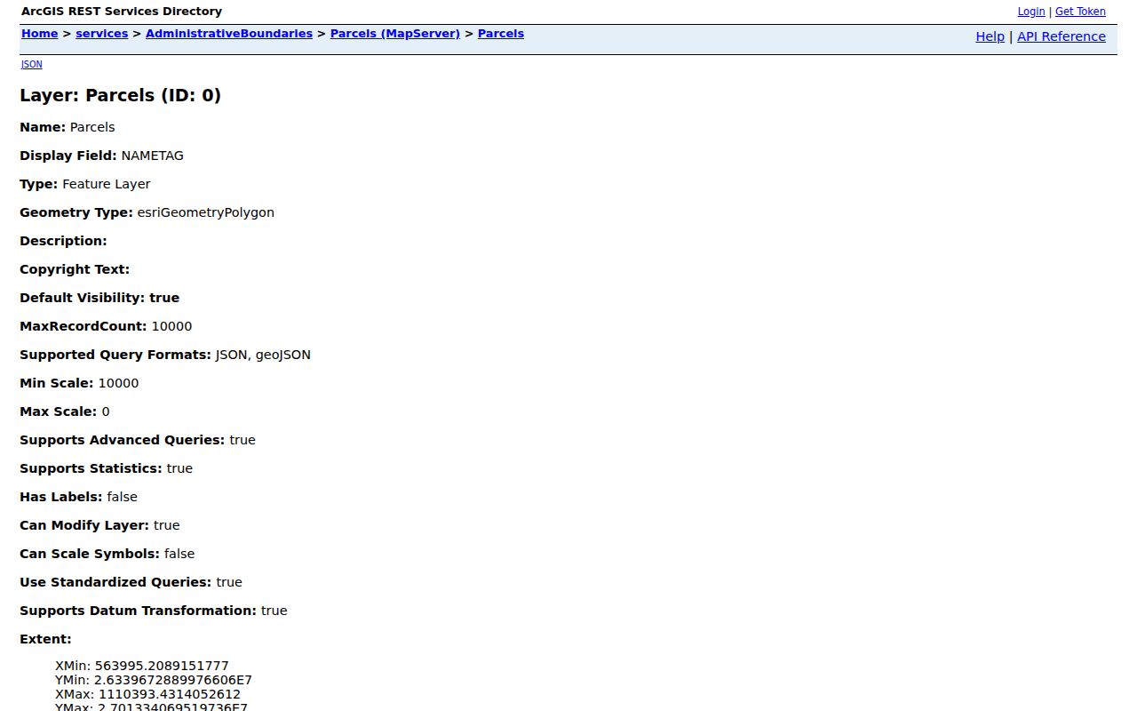
Use the displayed parcel number or street components to cross-check the Assessor card. GIS data can lag the official property record and county map data is labeled display-only with no warranty. When the selected parcel falls outside City limits, switch to the county map and the appropriate Clark County custodian rather than treating the City layer as countywide coverage.
Las Vegas Neighbor Map Context
Clark County GISMO Open Web is the regional map starting point for Assessor, zoning, planned land use, imagery, and related layers. GISMO describes itself as a regional system created in 1989 across more than 13 agencies. Its boundaries service includes Assessor Index, BookSection, Tract, ZIP Code, and Place layers. A query can be reproducible through the service, but the result still needs to match the APN and Assessor record.
Parcel geometry helps identify what counts as next door. A common area, a condominium master parcel, or a lot split by a street may complicate a simple visual sequence. Record the relationship rather than assuming every shape represents one ordinary address. For the same reason, use a selected parcel’s jurisdiction before following a city permit or county record link.
Las Vegas Neighbor Association Contacts
Neighborhood associations provide a community layer that parcel records cannot. The City’s registration rules allow people within a city-limit neighborhood to join, and registered board members must live or work within the boundaries. Registration is free, and the City describes development notices, community-center reservations, a Neighborhood Partners Fund, and tool lending among the benefits. Those facts identify a public contact route, not a membership directory.
| Association resource | Public contact route | What it can help identify |
|---|---|---|
| City Department of Neighborhood Services | 702-229-2330 or NSEvent@lasvegasnevada.gov | City registration, notices, programs, and the appropriate community contact |
| City neighborhood associations | City association information and registration channel | Eligibility, public benefits, and association-facing contact route |
| City CLV_NeighAreas GIS layer | GIS boundary and association metadata | Association name, boundary description, ward, public contacts, registered status, and SOS link where available |
| Clark County HOA registration layer | County registration or GIS inventory | Association name, management contact, subdivision, cross streets, and recording book or page metadata |
Association contact fields can be public, but they serve the organization, not an invitation to compile personal profiles. The county form’s management and recording details can connect a neighborhood label with a subdivision map. When a group is not in City limits, use the county association route and verify the community boundary before contacting anyone.
Las Vegas Neighbor Voter Visibility
The individual Clark County voter service asks for first name, last name, last four of an ID number, and date of birth. It does not display a public search-this-block mode. A permitted voter file can be active or all, comma-delimited, grouped by county or district, and updated weekly, but its use is limited by statute. An inactive address is not a current address.
NRS 293.558 protects Social Security numbers, driver-license or ID numbers, and email, while address and phone information may be withheld in the circumstances described by law. NRS 293.440 limits voter-list use to election-related purposes and restricts sale or unauthorized use. That makes voter data a controlled civic record, not a general directory for a Las Vegas block.
Las Vegas Neighbor History Leads
For a past block, begin with a dated parcel or legal description, then use local archives for a second line of evidence. UNLV Special Collections has Regional History Files, City Commission records, streets and street-name files, maps, newspapers, and microforms. The Cahlan Research Library is a free, noncirculating appointment room for phonebooks, yearbooks, newspapers, maps, manuscripts, and related local-history material. Ask for a street, subdivision, surname variant, and approximate year rather than a broad request for people in a neighborhood.
Historical directories and newspapers can show an old address or a community notice. The R.L. Polk Arrow map from 1957 to 1961, Sanborn references for 1928, 1943, and 1953, and UNLV street-name files can bridge an address that has changed. They remain dated leads. Pair them with the Recorder legal description and Assessor parcel identity before connecting a historic neighbor to a modern block.
Las Vegas Neighbor Privacy Limits
Public ownership and map records do not identify every person who lives at a location. Some people will not appear in an ownership record, and protected voter addresses have separate rules. Nevada’s Confidential Address Program gives qualifying survivors a designated fictitious address and confidential mail forwarding. A missing ordinary address can be a safety protection, not a reason to pursue more data. Motor-vehicle, utility, delivery, and nonpublic association membership information are not ordinary public block sources.
Nevada public-record law starts with NRS Chapter 239 but yields to a specific confidentiality statute. For an identifiable existing record, ask the custodian for the public portion and the precise legal reason for any withheld material. Do not repost sensitive material from an old record image, and do not try to reverse a protected address through map layers, association contacts, or other public sources.
Lawful use. Use Las Vegas block information for a personal, lawful purpose. Do not use it to stalk, harass, threaten, or intimidate anyone.
Las Vegas Neighbor Source Comparison
Official parcel and association sources state who holds the record, what date or field is being shown, and what access rule applies. Commercial neighbor tools are a category of compiled services. Their results can merge same-name people, lag property changes, mistake an owner for an occupant, omit protected records, or leave out the source date. A map-shaped list is not a verified block record.
| Source type | Useful strength | Limit to remember |
|---|---|---|
| Official GIS and Assessor records | Parcel geometry, APN, jurisdiction, assessed owner, and situs context | Does not prove everyone at a location |
| Recorder instrument index | Recorded parties, dates, and legal-description trail | Recorded party is not a current-occupancy finding |
| Association contact metadata | Community boundary and public organization contact | No general membership roster |
| Compiled commercial neighbor tools | May provide a lead to verify | Can be stale, merged, incomplete, or unclear about source dates |
For a question that matters, return to the official parcel record and retain the APN, jurisdiction, date, and source link. That creates a small, checkable record trail instead of a broad unverified list.